London Borough of Bexley
| London Borough of Bexley | |||
|---|---|---|---|
| — London borough — | |||
|
|||
| Motto: Boldly and Rightly | |||
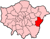
| Bexley shown within Greater London | |||
| Sovereign state | United Kingdom | ||
| Constituent country | England | ||
| Region | London | ||
| Ceremonial county | Greater London | ||
| Status | London borough | ||
| Admin HQ | Broadway, Bexleyheath | ||
| Incorporated | 1 April 1965 | ||
| Government | |||
| - Type | London borough council | ||
| - Body | Bexley London Borough Council | ||
| - Leadership | Leader & Cabinet (Conservative) | ||
| - Mayor | Cllr Bernard Clewes | ||
| - MPs | Teresa Pearce James Brokenshire David Evennett |
||
| - London Assembly | James Cleverly AM for Bexley and Bromley | ||
| - EU Parliament | London | ||
| Area | |||
| - Total | 23.4 sq mi (60.56 km2) | ||
| Area rank | 261st (of 326) | ||
| Population (2008 est.) | |||
| - Total | 223,300 | ||
| - Rank | 62nd (of 326) | ||
| - Density | 9,549.9/sq mi (3,687.3/km2) | ||
| - Ethnicity[1] | 84.0% White British 1.3% White Irish 2.7% Other White 0.5% White & Black Caribbean 0.3% White & Black African 0.5% White & Asian 0.5% Other Mixed 2.6% Indian 0.3% Pakistani 0.4% Bangladeshi 0.6% Other Asian 1.0% Black Caribbean 3.6% Black African 0.3% Other Black 0.8% Chinese 0.6% Other |
||
| Time zone | GMT (UTC0) | ||
| - Summer (DST) | BST (UTC+1) | ||
| Postcodes | {{{postcode_areas}}} | ||
| Police force | Metropolitan Police | ||
| Website | [LB Bexley LB Bexley] | ||

The London Borough of Bexley (pronunciation) lies to the south east of Greater London, one of those boroughs referred to as Outer London. It has common borders with the London Borough of Bromley to the south, the London Borough of Greenwich to the west and the River Thames is the northern boundary with the London Borough of Havering and the London Borough of Barking and Dagenham. To the east there is a boundary with the Dartford borough in Kent.
The borough is within the Thames Gateway, an area designated as a national priority for urban regeneration.
Contents |
History
Prior to the 19th century the area now forming the Borough was practically unoccupied: very few of the present settlements were mentioned in the Domesday Book, although the village of Bexley has a charter dated 814CE.[2] Erith was a port on the River Thames until the 17th century; the opening of the sewage works at nearby Crossness in the late 19th century turned it into an industrial town.
Today's settlement pattern is the result of the gradual extension of the London influence. Until the 19th century it was an area with few isolated buildings: examples being the Georgian Danson House and the Red House on Bexley Heath built for William Morris in 1859. With the coming of the railways building began apace, although the area is still composed of many disconnected settlements, interspersed with area of open ground and parks.
The London Borough of Bexley was formed in 1965, under the London Government Act 1963 from the Municipal Boroughs of Bexley and Erith; Crayford Urban District: and part of Chislehurst and Sidcup Urban District.[3]
The Council now styles itself the "London Borough of Bexley" in common with its formal name, although it previously styled itself "Bexley London Borough" until 1999 (possibly to maintain the link with its predecessor, Bexley Municipal Borough), and "Bexley Council" from 1999 to October 2007, when it reverted to its full formal name in conjunction with the adoption of a new Council logo bearing this name alongside the 1965 Coat of Arms.[4]
The town of Bexley, Ohio, a suburb of the city of Columbus, was named at the suggestion of an early resident, Mr. Kilbourne, in honour of his family's roots in Bexley, England. In addition, a suburb of Sydney, Australia bears the name of Bexley, New South Wales.
Governance
The administrative centre of the Borough is in Bexleyheath.
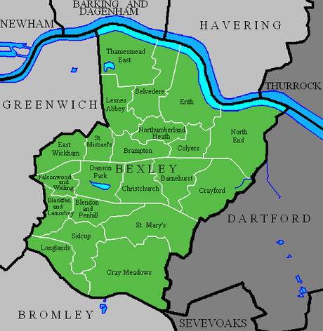
There are 21 wards represented on Bexley Council; each ward elects three councillors, 63 in all.[5] The wards are shown on the accompanying map.
All seats were up for re-election during the election on May 4, 2006. Until that date, Labour held control of the council by a margin of one (32 Labour to 31 Conservative councillors). In the election, the Conservatives took 23 seats from Labour, giving them the majority.
Insofar as central government is concerned, the borough is divided among the constituencies of Old Bexley and Sidcup; Erith and Thamesmead (shared with the London Borough of Greenwich); and Bexleyheath and Crayford
After the 2005 General Election, Erith and Thamesmead is represented by a Labour Party MP while the remaining two seats were held by the Conservative Party; although on 29 January 2008 the Conservative Party whip was withdrawn from Old Bexley and Sidcup's MP Derek Conway following alleged misuse of funds, leaving him as an Independent MP.
Geography
Bexley, lying as it does on the outer fringe of London, has many relatively large areas of open space. The ridge of higher ground in South London crosses the Borough from its high point of Shooters Hill, on the boundary with the London Borough of Greenwich, to end above the River Thames at Belvedere, where the land drops down to the old port of Erith. This high land, whose geology is the sand and pebbles of the Blackheath beds,[6] and which results in heathland, provided the line on the old Roman road (Watling Street) ran between Crayford and Welling. The land falls away to the north of the high ground, across the Erith Marshes to the River Thames, which here makes a loop to the north at Crossness. There is further ridge of less higher ground from the west terminating at Sidcup.[2]
Apart from the River Thames the other rivers within the Borough are the River Darent, which, with its tributary the River Cray and the smaller Stanham River, all form part of its north-eastern boundary; and the River Shuttle, a tributary of the Cray.
The major centres of settlement can be considered in two parts: the older established erstwhile villages; and the infill areas of suburban houses and centres.[7] Among the former are Erith, in the 17th century a port on the Thames, and an industrial town in the later 19th century; Bexleyheath, created at the same time on the London to Dover road. By the earlier 20th century, both were created Urban District Councils (UDC), as was Foots Cray (an ancient village site). Thamesmead, the "new town" built on what was the Erith Marshes, extends into the Borough: both Thamesmead North and South are located here. Crayford was mentioned in the Domesday Book, and its parish later included the hamlets of North End and Slade Green.
Smaller settlements include Welling, like Bexleyheath a staging post on the Dover Road, which was at one time of less importance than the nearby East Wickham (also an ancient village), was absorbed in Bexley UDC. Barnes Cray and North Cray were two hamlets in the Cray Valley; and Belvedere was the location of a medieval monastery.
The map of Bexley[8] shows that a large proportion of its area comprises suburbia. Some named places, like Albany Park and Barnehurst, are names given to developments engendered by the building of the railways. Some came into being when large estates and farmland were broken up for the sole purpose of suburban building: these include Blackfen, Lamorbey and part of Falconwood. Others simply reflect the nature of area: Lessness Heath; Longlands (part of Sidcup); Northumberland Heath and West Heath.
There are still open spaces, however, among the suburban streets and avenues. the Borough owns and maintains over one hundred parks and open spaces, large and small; and there is still a part of the Erith Marshes bordering the River Thames. The Crayford Marshes lie to the east of that river, as do Foots Cray Meadows further south.
The largest of the open spaces are Lesnes Abbey Woods, Danson Park and Hall Place Gardens. There are also many golf courses and sports fields, particularly to the west of Crayford.
Demographics
| Population | ||
|---|---|---|
| Year | Pop. | %± |
| 1801 | 4,165 | — |
| 1811 | 5,164 | 24.0% |
| 1821 | 6,279 | 21.6% |
| 1831 | 7,725 | 23.0% |
| 1841 | 9,616 | 24.5% |
| 1851 | 10,963 | 14.0% |
| 1861 | 16,477 | 50.3% |
| 1871 | 21,991 | 33.5% |
| 1881 | 27,505 | 25.1% |
| 1891 | 35,728 | 29.9% |
| 1901 | 46,904 | 31.3% |
| 1911 | 61,582 | 31.3% |
| 1921 | 77,747 | 26.2% |
| 1931 | 98,160 | 26.3% |
| 1941 | 139,861 | 42.5% |
| 1951 | 199,297 | 42.5% |
| 1961 | 208,138 | 4.4% |
| 1971 | 217,375 | 4.4% |
| 1981 | 214,352 | −1.4% |
| 1991 | 219,422 | 2.4% |
| 2001 | 218,307 | −0.5% |
| Source: A Vision of Britain through time | ||
In 1801, the civil parishes that form the modern borough had a total population of 4,165. This rose slowly throughout the 19th century, as the district became built up; reaching 10,963 in the middle of the century. When the railways arrived the rate of population growth increased. The population peaked in the 1970s, when industry began to relocate from London.
In the 2001 Census, the borough has a population of 218,307 – of whom 105,148 were male, and 113,159 female. Of those stating a choice, 72.94% described themselves as Christian, and 14.73% as having no religion. Of the population, 44.25% were in full-time employment and 11.63% in part-time employment – compared to a London average of 42.64% and 8.62%, respectively. Residents were predominantly owner-occupiers, with 31.71% owning their house outright, and a further 46.53% owning with a mortgage. Only 2.18% were in local authority housing, with a further 11.45% renting from a housing association, or other registered social landlord.[9]
Transport
There are three suburban railway lines crossing the Borough, all destined to come together at Dartford. The most northerly is the North Kent Line: stations from west to east within the Borough are at Belvedere, Erith and Slade Green. The Bexleyheath Line has stations at Falconwood, (of which is the nearest to Central London) Welling, Bexleyheath and Barnehurst; whilst the most southerly of the three lines, the Dartford Loop Line, serves Sidcup, Albany Park, Bexley and Crayford. In common with many other boroughs south of the Thames, Bexley has no London Underground lines.
The principal roads through the Borough include the A2 trunk road; the A20 (Sidcup By-Pass) which generally marks its southern boundary; the A207, which is the route of the erstwhile Watling Street; the A206 which takes traffic from Woolwich and Dartford; and the latter's newer counterpart, the A2016 through Thamesmead.
There are also some Long-distance footpaths in the Borough: among them the Thames Path and the London Outer Orbital Path. Bexley Borough has joined with three other adjoining boroughs to for the South East London Green Chain linking green spaces.
Education
Religion
The greater part of the population are nominal Anglicans, but a number of Roman Catholic churches and non-conformist congregations exist. Baptists, Plymouth Brethren, Methodist. In 2008 the former Crayford Methodist Church was purchased by the North West Kent Muslim Association to become a mosque serving Bexley and Dartford boroughs. There are no Jewish congregations. A small selection of churches is given here: St Paulinus, Crayford. Parts of this church date back to the 12th century with additions made in the later medieval period. St John the Baptist, Erith. A Norman church dating from the 12th century. The Wheatley Chapel was the burial place of successive Lords of the Manor. St Mary the Virgin, Bexley. The building dates from the 12th century, but much was restored in the 19th century. All Saints, Foots Cray. An ancient church, heavily restored in the 1860s St James, North Cray. An old church but rebuilt in the 19th century. Greek Orthodox Church, Welling. Probably of 13th century origin (formerly the parish church of St Michael). Christ Church, Erith. 19th century building. Grade II listed interior. Bethany Hall, Chapel Road, Bexleyheath, now a meeting house of the Plymouth Brethren though originally a Methodist chapel.
Public services
The London Borough of Bexley has three fire stations controlled by the London Fire Brigade within its boundary; those at Erith, Sidcup and Bexley. Bexley fire station's station ground is the largest of the three; covering 23.7 kmsq.[10] One pumping appliance, a fire rescue unit and an incident response unit reside there. Although it doesn't have the largest station ground, Erith was the busiest station in 2006/2007, responding to 1,314 incidents - two pumping appliances are based there. The third station, Sidcup, attended the least incidents in the same time period - 785. One pumping appliance is situated there. The three fire stations attended 3,095 incidents in the 2006/2007 period.
Twinning
References
- ↑ Data Management and Analysis Group, Greater London Authority, Demography Update October 2007, (2007)
- ↑ 2.0 2.1 A brief history of Bexley
- ↑ The other part of that Urban District becoming part of the London Borough of Bromley
- ↑ http://reports.bexley.gov.uk/TROVEPROGS/TROVEIIS.DLL?/IS=1061165973/LI=07_Decisions/ID=40/OS=2+12/DS=838/LO=1/XD=838/RW=1600/RH=1200/VD=07Decisi/WV=7/FR=1/ST=ac/AC=CA/FI=10/HU=EmptyURL reports.bexley.gov.uk
- ↑ Details of all councillors by ward
- ↑ The Rural Landscape of Kent, SG McRae and CP Burnham, Wye College, 1973
- ↑ Ideal Homes: Suburbia in Focus
- ↑ Map of Bexley
- ↑ Key Figures for 2001 Census: Census Area Statistics: Bexley accessed 25 February 2009
- ↑ London Fire Brigade, Bexley Profile
|
|||||||||||||||||||
|
||||||||||||||